
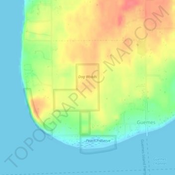
Dog Woods topographic map
Interactive map
Click on the map to display elevation.
About this map
Name: Dog Woods topographic map, elevation, terrain.
Average elevation: 24 m
Minimum elevation: 0 m
Maximum elevation: 60 m
Other topographic maps
Click on a map to view its topography, its elevation and its terrain.
Mount Vernon
United States > Washington > Skagit County
Mount Vernon, Skagit County, Washington, 98273, United States
Average elevation: 37 m
Sedro-Woolley
United States > Washington > Skagit County
Sedro-Woolley, Skagit County, Washington, United States
Average elevation: 28 m
Anacortes
United States > Washington > Skagit County
Anacortes, Skagit County, Washington, 98221, United States
Average elevation: 36 m
Belfast
United States > Washington > Skagit County
Belfast, Skagit County, Washington, United States
Average elevation: 67 m
Fidalgo Island
United States > Washington > Skagit County > Anacortes
Fidalgo Island, Anacortes, Skagit County, Washington, United States
Average elevation: 32 m
Conway
United States > Washington > Skagit County
Conway, Skagit County, Washington, 98238, United States
Average elevation: 7 m
Hope Island
United States > Washington > Skagit County
Hope Island, Skagit County, Washington, United States
Average elevation: 4 m
Stephen Mather Wilderness
United States > Washington > Skagit County
Stephen Mather Wilderness, Skagit County, Washington, United States
Average elevation: 1,120 m
Guemes
United States > Washington > Skagit County
Guemes, Skagit County, Washington, 98221, United States
Average elevation: 17 m
Dewey
United States > Washington > Skagit County > Anacortes
Dewey, Anacortes, Skagit County, Washington, 98221, United States
Average elevation: 35 m
Samish Island
United States > Washington > Skagit County
Samish Island, Skagit County, Washington, United States
Average elevation: 4 m
Alger
United States > Washington > Skagit County
Alger, Skagit County, Washington, United States
Average elevation: 130 m
Guemes Island
United States > Washington > Skagit County > Guemes
Guemes Island, Guemes, Skagit County, Washington, United States
Average elevation: 17 m
Burlington
United States > Washington > Skagit County
Burlington, Skagit County, Washington, 98233, United States
Average elevation: 12 m
Lake Cavanaugh
United States > Washington > Skagit County
Lake Cavanaugh, Skagit County, Washington, United States
Average elevation: 444 m
Forbidden Peak
United States > Washington > Skagit County
Forbidden Peak, Skagit County, Washington, United States
Average elevation: 2,105 m
Mount Erie
United States > Washington > Skagit County > Anacortes
Mount Erie, Anacortes, Skagit County, Washington, 98221, United States
Average elevation: 128 m
Concrete
United States > Washington > Skagit County
Concrete, Skagit County, Washington, United States
Average elevation: 125 m
La Conner
United States > Washington > Skagit County
La Conner, Skagit County, Washington, 98257, United States
Average elevation: 14 m
Anacortes
United States > Washington > Skagit County > Anacortes > Anacortes
Anacortes, Skagit County, Washington, 98221, United States
Average elevation: 37 m
Bow
United States > Washington > Skagit County
Bow, Skagit County, Washington, 98232, United States
Average elevation: 29 m
Cypress Island
United States > Washington > Skagit County
Cypress Island, Skagit County, Washington, United States
Average elevation: 64 m
Hamilton
United States > Washington > Skagit County
Hamilton, Skagit County, Washington, 98255, United States
Average elevation: 49 m
Whitmarsh Junction
United States > Washington > Skagit County > Anacortes > Whitmarsh Junction
Whitmarsh Junction, Anacortes, Skagit County, Washington, United States
Average elevation: 15 m
Marblemount
United States > Washington > Skagit County
Marblemount, Skagit County, Washington, United States
Average elevation: 249 m
Eldorado Peak
United States > Washington > Skagit County
Eldorado Peak, Skagit County, Washington, United States
Average elevation: 2,172 m
Rasar State Park
United States > Washington > Skagit County > Concrete
Rasar State Park, Concrete, Skagit County, Washington, 98237, United States
Average elevation: 69 m