
Sewanee topographic map
Interactive map
Click on the map to display elevation.
About this map
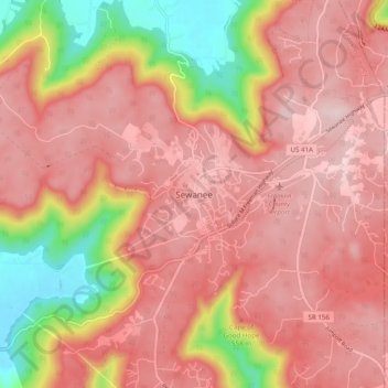
Name: Sewanee topographic map, elevation, terrain.
Average elevation: 512 m
Minimum elevation: 298 m
Maximum elevation: 621 m
Other topographic maps
Click on a map to view its topography, its elevation and its terrain.
Asia
United States > Tennessee > Franklin County
Asia, Franklin County, Middle Tennessee, Tennessee, United States
Average elevation: 297 m
Cowan
United States > Tennessee > Franklin County
Cowan, Franklin County, Middle Tennessee, Tennessee, United States
Average elevation: 312 m
Huntland
United States > Tennessee > Franklin County
Huntland, Franklin County, Middle Tennessee, Tennessee, United States
Average elevation: 282 m
Midway
United States > Tennessee > Franklin County
Midway, Franklin County, Middle Tennessee, Tennessee, 37375, United States
Average elevation: 579 m
Beech Hill
United States > Tennessee > Franklin County
Beech Hill, Franklin County, Middle Tennessee, Tennessee, United States
Average elevation: 280 m
Shady Grove
United States > Tennessee > Franklin County
Shady Grove, Franklin County, Middle Tennessee, Tennessee, United States
Average elevation: 302 m
Sherwood
United States > Tennessee > Franklin County
Sherwood, Franklin County, Middle Tennessee, Tennessee, 37376, United States
Average elevation: 344 m
Broadview
United States > Tennessee > Franklin County
Broadview, Franklin County, Middle Tennessee, Tennessee, United States
Average elevation: 294 m
City of Decherd Babe Ruth Ball Park
United States > Tennessee > Franklin County > Decherd
City of Decherd Babe Ruth Ball Park, Decherd, Franklin County, Middle Tennessee, Tennessee, United States
Average elevation: 300 m
Decherd
United States > Tennessee > Franklin County
Decherd, Franklin County, Middle Tennessee, Tennessee, United States
Average elevation: 301 m
Estill Springs
United States > Tennessee > Franklin County
Estill Springs, Franklin County, Middle Tennessee, Tennessee, 37330, United States
Average elevation: 293 m
Winchester
United States > Tennessee > Franklin County
Winchester, Franklin County, Middle Tennessee, Tennessee, United States
Average elevation: 293 m
Belvidere
United States > Tennessee > Franklin County
Belvidere, Franklin County, Middle Tennessee, Tennessee, 37306, United States
Average elevation: 309 m
Sewanee
United States > Tennessee > Franklin County > Sewanee
Sewanee, Franklin County, Tennessee, 37383, United States
Average elevation: 539 m