
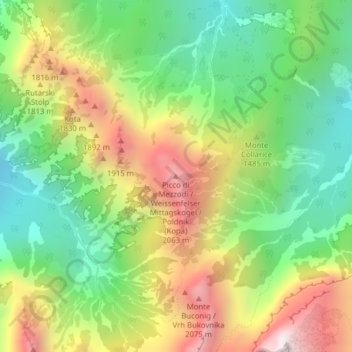
Weissenfelser Mittagskofel topographic map
Interactive map
Click on the map to display elevation.
About this map
Name: Weissenfelser Mittagskofel topographic map, elevation, terrain.
Average elevation: 1,496 m
Minimum elevation: 1,004 m
Maximum elevation: 2,178 m
Other topographic maps
Click on a map to view its topography, its elevation and its terrain.
Sankt Anton
Italien > Friaul-Julisch Venetien > Udine > Tarvis > Goggau
Sankt Anton, Goggau, Tarvis, Udine, Friaul-Julisch Venetien, 33018, Italien
Average elevation: 860 m
Weißenfels
Italien > Friaul-Julisch Venetien > Udine > Tarvis
Weißenfels, Tarvis, Udine, Friaul-Julisch Venetien, 33018, Italien
Average elevation: 967 m