
Marsimik La or Marsimek La 5,681.5 meters(18,640 ft) topographic map
Interactive map
Click on the map to display elevation.
About this map
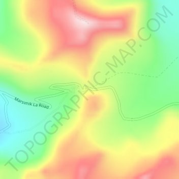
Name: Marsimik La or Marsimek La 5,681.5 meters(18,640 ft) topographic map, elevation, terrain.
Average elevation: 5,576 m
Minimum elevation: 5,380 m
Maximum elevation: 5,786 m
Other topographic maps
Click on a map to view its topography, its elevation and its terrain.
Beerwah
India > Jammu and Kashmir > Beerwah
Beerwah, Budgam District, Jammu and Kashmir, India
Average elevation: 1,785 m
Jammu
India > Jammu and Kashmir > Jammu
Jammu, Jammu District, Jammu and Kashmir, 180001, India
Average elevation: 367 m
Umrabad
India > Jammu and Kashmir > Umrabad
Umrabad, Budgam, Badgam, Jammu and Kashmir, 190012, India
Average elevation: 1,584 m
Sonamarg
India > Jammu and Kashmir > Sonamarg
Sonamarg, Ganderbal, Jammu and Kashmir, India
Average elevation: 3,354 m
Leh District
Leh District, Jammu and Kashmir, India
Average elevation: 4,794 m
Siachen Glacier
Siachen Glacier, Leh District, Jammu and Kashmir, India
Average elevation: 5,448 m
Central Chong Kumdan Glacier
Central Chong Kumdan Glacier, Leh District, Jammu and Kashmir, India
Average elevation: 5,823 m
Nun
Nun, Kargil District, Jammu and Kashmir, India
Average elevation: 5,988 m
South Rimo Glacier
South Rimo Glacier, Leh District, Jammu and Kashmir, India
Average elevation: 5,595 m