
L'Aubépin topographic map
Interactive map
Click on the map to display elevation.
About this map
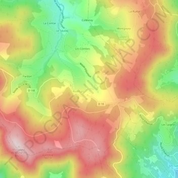
Name: L'Aubépin topographic map, elevation, terrain.
Average elevation: 686 m
Minimum elevation: 450 m
Maximum elevation: 883 m
Other topographic maps
Click on a map to view its topography, its elevation and its terrain.
Pardon
France > Auvergne-Rhône-Alpes > Rhône > Deux-Grosnes > Avenas
Pardon, Avenas, Deux-Grosnes, Villefranche-sur-Saône, Rhône, Auvergne-Rhône-Alpes, France métropolitaine, 69430, France
Average elevation: 685 m