
City of Oneonta topographic map
Interactive map
Click on the map to display elevation.
About this map
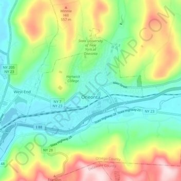
Name: City of Oneonta topographic map, elevation, terrain.
Average elevation: 433 m
Minimum elevation: 319 m
Maximum elevation: 655 m
Other topographic maps
Click on a map to view its topography, its elevation and its terrain.
Village of Otego
United States > New York > Otsego County
Village of Otego, Town of Otego, Otsego County, New York, United States
Average elevation: 364 m
Town of Unadilla
United States > New York > Otsego County
Town of Unadilla, Otsego County, New York, United States
Average elevation: 433 m
South Edmeston
United States > New York > Otsego County > Town of Edmeston
South Edmeston, Town of Edmeston, Otsego County, New York, United States
Average elevation: 386 m
Franklin Mountain
United States > New York > Otsego County
Franklin Mountain, Town of Oneonta, Otsego County, New York, 13820, United States
Average elevation: 533 m
Town of Middlefield
United States > New York > Otsego County
Town of Middlefield, Otsego County, New York, 13450, United States
Average elevation: 502 m
Town of Otego
United States > New York > Otsego County
Town of Otego, Otsego County, New York, 13825, United States
Average elevation: 453 m
West Edmeston
United States > New York > Otsego County > Town of Edmeston
West Edmeston, Town of Edmeston, Otsego County, New York, 13485, United States
Average elevation: 416 m
Mount Vision
United States > New York > Otsego County
Mount Vision, Town of Laurens, Otsego County, New York, United States
Average elevation: 415 m
Town of Cherry Valley
United States > New York > Otsego County
Town of Cherry Valley, Otsego County, New York, 13320, United States
Average elevation: 473 m
South Hartwick
United States > New York > Otsego County > Town of Hartwick
South Hartwick, Town of Hartwick, Otsego County, New York, 13810, United States
Average elevation: 432 m
Town of Richfield
United States > New York > Otsego County
Town of Richfield, Otsego County, New York, 13439, United States
Average elevation: 465 m
Village of Unadilla
United States > New York > Otsego County
Village of Unadilla, Town of Unadilla, Otsego County, New York, United States
Average elevation: 359 m
Burlington Flats
United States > New York > Otsego County > Town of Burlington
Burlington Flats, Town of Burlington, Otsego County, New York, United States
Average elevation: 448 m
Town of Burlington
United States > New York > Otsego County
Town of Burlington, Otsego County, New York, United States
Average elevation: 498 m
Town of Maryland
United States > New York > Otsego County
Town of Maryland, Otsego County, New York, 12155, United States
Average elevation: 490 m
Town of New Lisbon
United States > New York > Otsego County
Town of New Lisbon, Otsego County, New York, United States
Average elevation: 475 m
Town of Oneonta
United States > New York > Otsego County
Town of Oneonta, Otsego County, New York, 13861, United States
Average elevation: 456 m
Town of Laurens
United States > New York > Otsego County
Town of Laurens, Otsego County, New York, 13796, United States
Average elevation: 471 m
Village of Milford
United States > New York > Otsego County
Village of Milford, Town of Milford, Otsego County, New York, United States
Average elevation: 388 m
Oneonta
United States > New York > Otsego County > City of Oneonta > Oneonta
Oneonta, City of Oneonta, Otsego County, New York, 13820, United States
Average elevation: 447 m
Town of Decatur
United States > New York > Otsego County
Town of Decatur, Otsego County, New York, United States
Average elevation: 589 m
Town of Worcester
United States > New York > Otsego County
Town of Worcester, Otsego County, New York, United States
Average elevation: 553 m
Town of Exeter
United States > New York > Otsego County
Town of Exeter, Plainfield, Otsego County, New York, 13457, United States
Average elevation: 486 m
Town of Springfield
United States > New York > Otsego County
Town of Springfield, Otsego County, New York, United States
Average elevation: 456 m
Town of Hartwick
United States > New York > Otsego County > Town of Hartwick
Town of Hartwick, Otsego County, New York, United States
Average elevation: 489 m
Town of Westford
United States > New York > Otsego County > Town of Westford
Town of Westford, Otsego County, New York, 13488, United States
Average elevation: 542 m
Village of Richfield Springs
United States > New York > Otsego County
Village of Richfield Springs, Town of Richfield, Otsego County, New York, United States
Average elevation: 416 m
Schenevus
United States > New York > Otsego County > Town of Maryland > Schenevus
Schenevus, Town of Maryland, Otsego County, New York, United States
Average elevation: 435 m
Maryland
United States > New York > Otsego County > Town of Maryland > Maryland
Maryland, Town of Maryland, Otsego County, New York, United States
Average elevation: 464 m
Town of Butternuts
United States > New York > Otsego County
Town of Butternuts, Otsego County, New York, United States
Average elevation: 445 m
Morris
United States > New York > Otsego County > Morris
Morris, Town of Morris, Otsego County, New York, United States
Average elevation: 379 m
Tuscan
United States > New York > Otsego County > Town of Worcester
Tuscan, Town of Worcester, Otsego County, New York, 12127, United States
Average elevation: 507 m
Silver Lake
United States > New York > Otsego County > Silver Lake
Silver Lake, Town of Pittsfield, Otsego County, New York, 13411, United States
Average elevation: 395 m
Village of Cooperstown
United States > New York > Otsego County
Village of Cooperstown, Town of Otsego, Otsego County, New York, United States
Average elevation: 417 m
Briar Hill
United States > New York > Otsego County > Town of Burlington
Briar Hill, Town of Burlington, Otsego County, New York, United States
Average elevation: 557 m
Village of Gilbertsville
United States > New York > Otsego County
Village of Gilbertsville, Town of Butternuts, Otsego County, New York, 13776, United States
Average elevation: 372 m