
Thank you for supporting this site ❤️
Make a donation
Make a donation
York County topographic map
Click on the map to display elevation.
Thank you for supporting this site ❤️
Make a donation
Make a donation
About this map
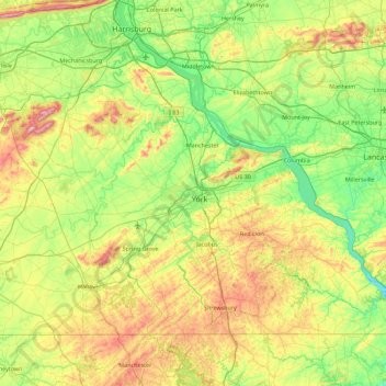
Name: York County topographic map, elevation, terrain.
Location: York County, Pennsylvania, United States (39.71992 -77.13714 40.22616 -76.23869)
Average elevation: 172 m
Minimum elevation: 32 m
Maximum elevation: 471 m
Thank you for supporting this site ❤️
Make a donation
Make a donation
Other topographic maps
Click on a map to view its topography, its elevation and its terrain.
Barlow Hill
United States > Pennsylvania > Tioga County > Charleston Township
Average elevation: 473 m