
Tevere topographic map
Interactive map
Click on the map to display elevation.
About this map
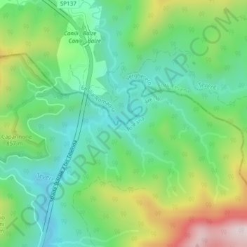
Name: Tevere topographic map, elevation, terrain.
Location: Tevere, Pieve Santo Stefano, Arezzo, Toscana, Italia (43.75375 12.04274 43.75413 12.04426)
Average elevation: 747 m
Minimum elevation: 570 m
Maximum elevation: 1,107 m
Other topographic maps
Click on a map to view its topography, its elevation and its terrain.
Monte della Zucca
Italia > Toscana > Arezzo > Pieve Santo Stefano
Monte della Zucca, Pieve Santo Stefano, Arezzo, Toscana, Italia
Average elevation: 972 m
Montecavallo
Italia > Toscana > Arezzo > Pieve Santo Stefano
Montecavallo, Pieve Santo Stefano, Arezzo, Toscana, Italia
Average elevation: 879 m