
Kaikoura topographic map
Interactive map
Click on the map to display elevation.
About this map
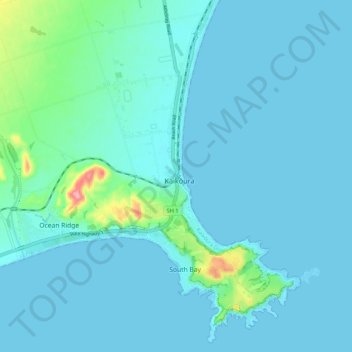
Name: Kaikoura topographic map, elevation, terrain.
Location: Kaikoura, Kaikōura District, Canterbury, 7300, New Zealand (-42.43949 173.64009 -42.35949 173.72009)
Average elevation: 15 m
Minimum elevation: 0 m
Maximum elevation: 138 m
Other topographic maps
Click on a map to view its topography, its elevation and its terrain.
Mount Fyffe
New Zealand > Canterbury > Kaikoura
Mount Fyffe, Kaikōura, Canterbury, New Zealand
Average elevation: 1,142 m
Constitution Hill
New Zealand > Canterbury > Kaikoura
Constitution Hill, Kaikōura, Canterbury, New Zealand
Average elevation: 1,566 m