
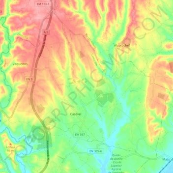
Casével e Vaqueiros topographic map
Interactive map
Click on the map to display elevation.
About this map
Name: Casével e Vaqueiros topographic map, elevation, terrain.
Location: Casével e Vaqueiros, Santarém, Portugal (39.36699 -8.65942 39.43351 -8.55690)
Average elevation: 66 m
Minimum elevation: 12 m
Maximum elevation: 124 m
Other topographic maps
Click on a map to view its topography, its elevation and its terrain.
Póvoa da Isenta
Portugal > Santarém > Santarém
Póvoa da Isenta, Santarém, Portugal
Average elevation: 49 m
Arneiro das Milhariças
Portugal > Santarém > Santarém
Arneiro das Milhariças, Santarém, Portugal
Average elevation: 99 m
Póvoa de Santarém
Portugal > Santarém > Santarém
Póvoa de Santarém, Santarém, 2000, Portugal
Average elevation: 61 m
Amiais de Baixo
Portugal > Santarém > Santarém
Amiais de Baixo, Santarém, 2835-333, Portugal
Average elevation: 132 m
Vale de Santarém
Portugal > Santarém > Santarém
Vale de Santarém, Santarém, 2005-039, Portugal
Average elevation: 35 m