
Saint-Avold topographic map
Interactive map
Click on the map to display elevation.
About this map
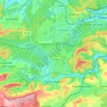
Name: Saint-Avold topographic map, elevation, terrain.
Average elevation: 271 m
Minimum elevation: 216 m
Maximum elevation: 392 m
Other topographic maps
Click on a map to view its topography, its elevation and its terrain.
Cité Émile Huchet
France > Grand Est > Moselle > Saint-Avold
Cité Émile Huchet, Saint-Avold, Forbach-Boulay-Moselle, Moselle, Grand Est, Metropolitan France, 57500, France
Average elevation: 253 m