
Forbach topographic map
Interactive map
Click on the map to display elevation.
About this map
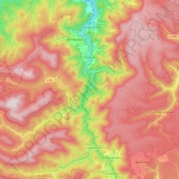
Name: Forbach topographic map, elevation, terrain.
Location: Forbach, Landkreis Rastatt, Baden-Württemberg, 76596, Duitsland (48.58636 8.22205 48.72035 8.43619)
Average elevation: 717 m
Minimum elevation: 200 m
Maximum elevation: 1,050 m
Other topographic maps
Click on a map to view its topography, its elevation and its terrain.
Raumünzach
Duitsland > Baden-Württemberg > Landkreis Rastatt > Forbach
Raumünzach, Forbach, Landkreis Rastatt, Baden-Württemberg, 76596, Duitsland
Average elevation: 608 m
Bermersbach
Duitsland > Baden-Württemberg > Landkreis Rastatt
Bermersbach, Forbach, Landkreis Rastatt, Baden-Württemberg, 76596, Duitsland
Average elevation: 504 m
Riegel
Duitsland > Baden-Württemberg > Landkreis Rastatt > Bühl
Riegel, Bühl, Vereinbarte Verwaltungsgemeinschaft Bühl, Landkreis Rastatt, Baden-Württemberg, 77815, Duitsland
Average elevation: 256 m