
Mandalika topographic map
Interactive map
Click on the map to display elevation.
About this map
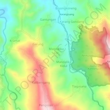
Name: Mandalika topographic map, elevation, terrain.
Location: Mandalika, Pemalang, Central Java, Java, Indonesia (-7.18369 109.47994 -7.14369 109.51994)
Average elevation: 442 m
Minimum elevation: 273 m
Maximum elevation: 684 m
Other topographic maps
Click on a map to view its topography, its elevation and its terrain.
Gunung Singa
Indonesia > Central Java > Pemalang > Majakerta
Gunung Singa, Majakerta, Pemalang, Central Java, Java, Indonesia
Average elevation: 418 m