
Summit Hill topographic map
Interactive map
Click on the map to display elevation.
About this map
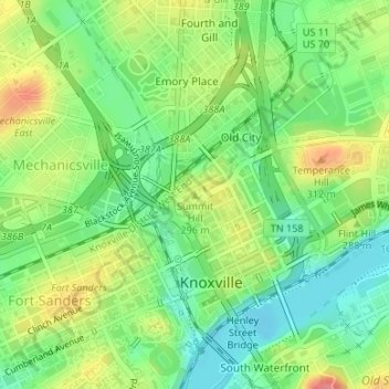
Name: Summit Hill topographic map, elevation, terrain.
Average elevation: 278 m
Minimum elevation: 246 m
Maximum elevation: 324 m
Other topographic maps
Click on a map to view its topography, its elevation and its terrain.
University of Tennessee
United States > Tennessee > Knox County > Knoxville
University of Tennessee, Knoxville, Knox County, East Tennessee, Tennessee, United States
Average elevation: 272 m
Knoxville
United States > Tennessee > Knox County > Knoxville
Knoxville, Knox County, Tennessee, 37996-4134, United States
Average elevation: 304 m
Buffat Heights
United States > Tennessee > Knox County > Knoxville
Buffat Heights, Knoxville, Knox County, East Tennessee, Tennessee, 37914, United States
Average elevation: 303 m
Ijams Nature Center
United States > Tennessee > Knox County > Knoxville
Ijams Nature Center, Alamo Avenue Southeast, Knoxville, Knox County, East Tennessee, Tennessee, 37920, United States
Average elevation: 268 m
Vestal
United States > Tennessee > Knox County > Knoxville
Vestal, Knoxville, Knox County, Tennessee, 37920, United States
Average elevation: 284 m
Ten Mile
United States > Tennessee > Knox County > Knoxville
Ten Mile, Knoxville, Knox County, Tennessee, 37923, United States
Average elevation: 291 m
Dante
United States > Tennessee > Knox County > Knoxville > Dante
Dante, Knoxville, Knox County, Tennessee, 37912, United States
Average elevation: 332 m
Highland Park
United States > Tennessee > Knox County > Knoxville > Highland Park
Highland Park, Knoxville, Knox County, Tennessee, 37918, United States
Average elevation: 341 m
Ijams Nature Center
United States > Tennessee > Knox County > Knoxville
Ijams Nature Center, Knoxville, Knox County, Tennessee, United States
Average elevation: 268 m
Arlington
United States > Tennessee > Knox County > Knoxville > Arlington
Arlington, Knoxville, Knox County, Tennessee, 37917, United States
Average elevation: 310 m
Island Home
United States > Tennessee > Knox County > Knoxville > Island Home
Island Home, Knoxville, Knox County, Tennessee, 37914:37915, United States
Average elevation: 276 m