
Tikhfist topographic map
Interactive map
Click on the map to display elevation.
About this map
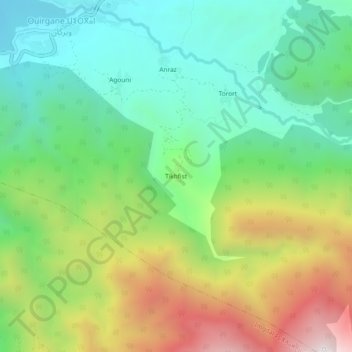
Name: Tikhfist topographic map, elevation, terrain.
Average elevation: 1,299 m
Minimum elevation: 850 m
Maximum elevation: 2,109 m
Other topographic maps
Click on a map to view its topography, its elevation and its terrain.
Marigha
Morocco > cercle d'Asni > Ouirgane
Marigha, Ouirgane, caïdat de Ouirgane, cercle d'Asni, Al Haouz Province, Marrakech-Safi, Morocco
Average elevation: 1,137 m