
Refugi de Saboredo topographic map
Interactive map
Click on the map to display elevation.
About this map
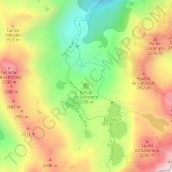
Name: Refugi de Saboredo topographic map, elevation, terrain.
Average elevation: 2,392 m
Minimum elevation: 1,990 m
Maximum elevation: 2,802 m
Other topographic maps
Click on a map to view its topography, its elevation and its terrain.
Refugi del Gerdar
Espagne > Catalogne > Lérida > Alt Àneu > la Bonaigua de Baix
Refugi del Gerdar, C-142z, la Bonaigua de Baix, Alt Àneu, Pallars-Supérieur, Lérida, Catalogne, 25286, Espagne
Average elevation: 1,831 m