
Make a donation
Los Angeles topographic map
Click on the map to display elevation.
Make a donation
Los Angeles
Los Angeles is characterized by a diverse and dynamic topography. The city is predominantly situated in a basin bordered by mountain ranges, including the Santa Monica Mountains to the north and the San Gabriel Mountains to the east, with elevations reaching up to about 10,000 feet (3,048 meters) in certain areas. This geographical setup results in varying elevations across the city, with an average elevation of approximately 472 feet (144 meters). The terrain features rolling hills, valleys, and coastal plains that gently slope towards the Pacific Ocean. Notable geographical features include the Los Angeles River, which flows through the city, and various canyons that add to the region's rugged charm. This blend of hills and flatlands creates a unique urban landscape, offering both scenic vistas and opportunities for outdoor recreation.
Make a donation
About this map
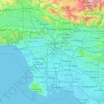
Name: Los Angeles topographic map, elevation, terrain.
Location: Los Angeles, Los Angeles County, California, United States (33.65954 -118.66818 34.33731 -118.15530)
Average elevation: 241 m
Minimum elevation: -2 m
Maximum elevation: 2,428 m
Make a donation