Geolocate

Skye topographic map

Click on the map to display elevation.

Skye

Beyond Loch Snizort to the west of Trotternish is the Waternish peninsula, which ends in Ardmore Point's double rock arch. Duirinish peninsula is separated from Waternish by Loch Dunvegan, which contains the island of Isay. It is ringed by sea cliffs that reach 296 metres (971 feet) on the west at Waterstein Head and on the northwest at Biod an Athair where, a metre from the summit trig pillar, the cliffs drop 1,029 feet (314 metres) to the ocean. Oolitic loam provides good arable land in the main valley. Lochs Bracadale and Harport and the island of Wiay lie between Duirinish and Minginish, which includes the narrower defiles of Talisker and Glen Brittle and whose beaches are formed from black basaltic sands. Strathaird is a relatively small peninsula close to the Cuillin hills with only a few crofting communities, the island of Soay lies offshore. The bedrock of Sleat in the south is Torridonian sandstone, which produces poor soils and boggy ground, although its lower elevations and relatively sheltered eastern shores enable a lush growth of hedgerows and crops. The islands of Raasay, Rona, Scalpay and Pabay all lie to the north and east between Skye and the mainland.

Wikipedia (CC-BY-SA 3.0)

About this map

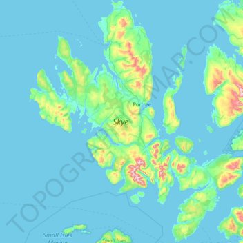
Name: Skye topographic map, elevation, terrain.

Location: Skye, Highland, Scotland, United Kingdom (57.01782 -6.78982 57.70824 -5.64758)

Average elevation: 63 m

Minimum elevation: 0 m

Maximum elevation: 921 m

Other topographic maps

Click on a map to view its topography, its elevation and its terrain.

Ben Nevis

United Kingdom > Scotland > Highland

Ben Nevis has a highland (alpine) maritime (oceanic) polar climate (ET climate in the Köppen classification). Ben Nevis's elevation, maritime location and topography frequently lead to cool and cloudy weather conditions, which can pose a danger to ill-equipped walkers. According to the observations carried…

Average elevation: 912 m

Quiraing

United Kingdom > Scotland > Highland

Average elevation: 298 m

Inverness

United Kingdom > Scotland > Highland

Average elevation: 163 m

Brae Roy Lodge

United Kingdom > Scotland > Highland

Average elevation: 371 m

Invergordon

United Kingdom > Scotland > Highland

Average elevation: 24 m

The Quiraing

United Kingdom > Scotland > Highland

Average elevation: 305 m

Aviemore

United Kingdom > Scotland > Highland

Average elevation: 331 m

Fort William

United Kingdom > Scotland > Highland

Fort William has an oceanic climate (Cfb) with moderate, but generally cool, temperatures and abundant precipitation. In the towns immediate vicinity, there are significant variations in elevation, which leads to some uninhabited areas near the town having a subpolar oceanic climate (Cfc), or, at the absolute…

Average elevation: 122 m

Sgùrr a' Mhaoraich

United Kingdom > Scotland > Highland

Average elevation: 662 m

Glencoe

United Kingdom > Scotland > Highland

Average elevation: 114 m

Grampian Mountains

United Kingdom > Scotland > Highland

Average elevation: 775 m

Arisaig

United Kingdom > Scotland > Highland

Average elevation: 54 m

Suilven

United Kingdom > Scotland > Highland

Average elevation: 293 m

Beinn Mheadhonach

United Kingdom > Scotland > Highland

Average elevation: 336 m

Sgùrr na Sgine

United Kingdom > Scotland > Highland

Average elevation: 605 m

River Garry

United Kingdom > Scotland > Highland

Average elevation: 254 m

Caol

United Kingdom > Scotland > Highland

Average elevation: 38 m

Sgùrr nan Gillean

United Kingdom > Scotland > Highland

Average elevation: 496 m

Glen Nevis

United Kingdom > Scotland > Highland > Achriabhach

Average elevation: 265 m

Achnacarry

United Kingdom > Scotland > Highland

Average elevation: 183 m

Alness

United Kingdom > Scotland > Highland

Average elevation: 66 m

Lochcarron

United Kingdom > Scotland > Highland

Average elevation: 67 m

Lochinver

United Kingdom > Scotland > Highland

Average elevation: 62 m

Càrn Mòr Dearg

United Kingdom > Scotland > Highland

Average elevation: 892 m

Càrn Eige

United Kingdom > Scotland > Highland

Carn Eighe (Scottish Gaelic: Càrn Èite) is a mountain in the Northwest Highlands of Scotland. Rising to 1,183 metres (3,881 ft) above sea level, it is the highest mountain in Scotland north of the Great Glen, the twelfth-highest in the British Isles, and, in terms of relative height (topographic prominence),…

Average elevation: 867 m

Beinn Alligin

United Kingdom > Scotland > Highland

Average elevation: 566 m

Ben Hope

United Kingdom > Scotland > Highland

Average elevation: 490 m

Quinag

United Kingdom > Scotland > Highland

Average elevation: 368 m

Foinaven

United Kingdom > Scotland > Highland

Average elevation: 552 m

Sgùrr Fhuaran

United Kingdom > Scotland > Highland

The mountain reaches a height of 1,067 metres (3,501 ft) and qualifies as a Munro and a Marilyn; it is the highest point for a significant distance, having a sizeable topographic prominence of 663 metres (2,175 ft) and giving extensive views from its summit.

Average elevation: 604 m

Ainshval

United Kingdom > Scotland > Highland

Average elevation: 427 m

Roineval

United Kingdom > Scotland > Highland

Average elevation: 290 m

Sgurr an Lochain

United Kingdom > Scotland > Highland

Average elevation: 621 m

Sgùrr nan Eag

United Kingdom > Scotland > Highland

Average elevation: 528 m

Loch Ainort

United Kingdom > Scotland > Highland

Average elevation: 55 m

Loch Eishort

United Kingdom > Scotland > Highland > Tarskavaig

Average elevation: 74 m

Uig

United Kingdom > Scotland > Highland

Average elevation: 103 m

Loch Fannich

United Kingdom > Scotland > Highland

Average elevation: 463 m

Erchless Castle

United Kingdom > Scotland > Highland > Struy

Average elevation: 131 m

Raddery

United Kingdom > Scotland > Highland > Fortrose

Average elevation: 129 m

Corpach

United Kingdom > Scotland > Highland

Average elevation: 83 m

Ardnarff

United Kingdom > Scotland > Highland

Average elevation: 156 m

Whitebridge

United Kingdom > Scotland > Highland

Average elevation: 223 m

Langdale

United Kingdom > Scotland > Highland

Average elevation: 115 m

Davochfin

United Kingdom > Scotland > Highland > Dornoch

Average elevation: 13 m

Melvaig

United Kingdom > Scotland > Highland

Average elevation: 90 m

Strathpeffer

United Kingdom > Scotland > Highland

It lies in a strath 5 miles (8 km) west of Dingwall, with the elevation ranging from 60 to 120 m (200 to 400 ft) above sea level. Sheltered on the west and north, it has a comparatively dry and warm climate.

Average elevation: 127 m

Mellon Charles

United Kingdom > Scotland > Highland

Average elevation: 30 m

Invermoriston

United Kingdom > Scotland > Highland

Average elevation: 212 m

Sgùrr Alasdair

United Kingdom > Scotland > Highland

Average elevation: 576 m

Newtonmore

United Kingdom > Scotland > Highland

Newtonmore is located within the Cairngorms National Park, approximately 3 miles (5 km) southwest of Kingussie and 15 miles (24 km) southwest of Aviemore. It is on the northeastern bank of the River Spey, between the River Calder and the Allt Lairaidh, at an altitude of approximately 250 metres (820 ft).

Average elevation: 283 m

Avoch

United Kingdom > Scotland > Highland

Average elevation: 50 m

Scotscalder

United Kingdom > Scotland > Highland

Average elevation: 72 m

Wick

United Kingdom > Scotland > Highland

Average elevation: 20 m

Kingussie

United Kingdom > Scotland > Highland

Average elevation: 338 m

Thurso

United Kingdom > Scotland > Highland

Average elevation: 25 m

Lairg

United Kingdom > Scotland > Highland

Average elevation: 129 m

Insh

United Kingdom > Scotland > Highland

Average elevation: 275 m

Lyth

United Kingdom > Scotland > Highland

Average elevation: 29 m

Scottish Highlands

United Kingdom > Scotland > Highland

The entire region was covered by ice sheets during the Pleistocene ice ages, save perhaps for a few nunataks. The complex geomorphology includes incised valleys and lochs carved by the action of mountain streams and ice, and a topography of irregularly distributed mountains whose summits have similar heights…

Average elevation: 907 m

Glasnakille

United Kingdom > Scotland > Highland

Average elevation: 39 m

Ballachulish

United Kingdom > Scotland > Highland

Average elevation: 160 m

Clachtoll

United Kingdom > Scotland > Highland

Average elevation: 38 m

Staffin

United Kingdom > Scotland > Highland

Average elevation: 42 m

Dounreay

United Kingdom > Scotland > Highland

Average elevation: 36 m

Achmelvich

United Kingdom > Scotland > Highland

Average elevation: 58 m

Inverinate

United Kingdom > Scotland > Highland

Average elevation: 186 m

Tongue

United Kingdom > Scotland > Highland

Average elevation: 91 m

Knockdee

United Kingdom > Scotland > Highland

Average elevation: 66 m

North Watten

United Kingdom > Scotland > Highland

Average elevation: 51 m

Poolewe

United Kingdom > Scotland > Highland

Average elevation: 58 m

Altnaharra

United Kingdom > Scotland > Highland

Average elevation: 126 m

Forsinard

United Kingdom > Scotland > Highland

Average elevation: 171 m

Fearnmore

United Kingdom > Scotland > Highland

Average elevation: 22 m

Milovaig

United Kingdom > Scotland > Highland

Average elevation: 72 m

Tarvie

United Kingdom > Scotland > Highland

Average elevation: 135 m

The Storr

United Kingdom > Scotland > Highland

Average elevation: 396 m

Halkirk

United Kingdom > Scotland > Highland

Average elevation: 49 m

Foyers

United Kingdom > Scotland > Highland

Average elevation: 124 m

Spean Bridge

United Kingdom > Scotland > Highland

Average elevation: 141 m

Gillock

United Kingdom > Scotland > Highland > Wick

Average elevation: 22 m

Grantown-on-Spey

United Kingdom > Scotland > Highland

Average elevation: 271 m

Farrmheall

United Kingdom > Scotland > Highland

Average elevation: 281 m

Laide

United Kingdom > Scotland > Highland

Average elevation: 47 m

Gartymore

United Kingdom > Scotland > Highland > Portgower

Average elevation: 94 m

Leanachan Forest

United Kingdom > Scotland > Highland > Torlundy

Average elevation: 100 m

Aultbea

United Kingdom > Scotland > Highland

Average elevation: 44 m

Portree

United Kingdom > Scotland > Highland

Average elevation: 121 m

Kilbride

United Kingdom > Scotland > Highland

Average elevation: 116 m

Corry Bruoch Beg

United Kingdom > Scotland > Highland

Average elevation: 335 m

Kylesku

United Kingdom > Scotland > Highland

Average elevation: 82 m