
Irving topographic map
Interactive map
Click on the map to display elevation.
About this map
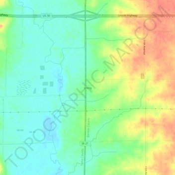
Name: Irving topographic map, elevation, terrain.
Location: Irving, Benton County, Iowa, United States (41.92774 -92.31698 41.96774 -92.27698)
Average elevation: 259 m
Minimum elevation: 236 m
Maximum elevation: 292 m
Other topographic maps
Click on a map to view its topography, its elevation and its terrain.
Walford
United States > Iowa > Benton County
Walford, Benton County, Iowa, 52351, United States
Average elevation: 251 m
Van Horne
United States > Iowa > Benton County
Van Horne, Benton County, Iowa, United States
Average elevation: 286 m
Norway
United States > Iowa > Benton County
Norway, Benton County, Iowa, United States
Average elevation: 247 m
Newhall
United States > Iowa > Benton County
Newhall, Benton County, Iowa, United States
Average elevation: 273 m
Watkins
United States > Iowa > Benton County
Watkins, Benton County, Iowa, 52354, United States
Average elevation: 254 m
Urbana
United States > Iowa > Benton County
Urbana, Benton County, Iowa, 52345, United States
Average elevation: 271 m
Shellsburg
United States > Iowa > Benton County
Shellsburg, Benton County, Iowa, United States
Average elevation: 249 m
Mount Auburn
United States > Iowa > Benton County
Mount Auburn, Benton County, Iowa, United States
Average elevation: 260 m
Luzerne
United States > Iowa > Benton County
Luzerne, Benton County, Iowa, United States
Average elevation: 274 m
Vinton
United States > Iowa > Benton County
Vinton, Benton County, Iowa, United States
Average elevation: 248 m
Keystone
United States > Iowa > Benton County
Keystone, Benton County, Iowa, United States
Average elevation: 272 m
Garrison
United States > Iowa > Benton County
Garrison, Benton County, Iowa, United States
Average elevation: 274 m
Atkins
United States > Iowa > Benton County
Atkins, Benton County, Iowa, United States
Average elevation: 263 m
Blairstown
United States > Iowa > Benton County
Blairstown, Benton County, Iowa, United States
Average elevation: 260 m
Belle Plaine
United States > Iowa > Benton County
Belle Plaine, Benton County, Iowa, 52208, United States
Average elevation: 246 m