
Piornedo topographic map
Interactive map
Click on the map to display elevation.
About this map
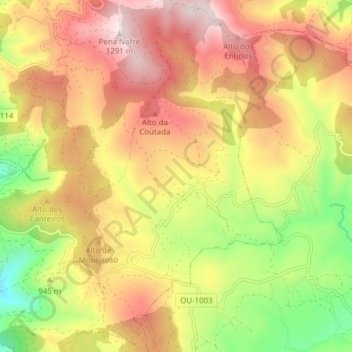
Name: Piornedo topographic map, elevation, terrain.
Location: Piornedo, Castrelo do Val, Verín, Orense, Galicia, España (41.98653 -7.35872 42.04358 -7.31517)
Average elevation: 967 m
Minimum elevation: 617 m
Maximum elevation: 1,274 m
Other topographic maps
Click on a map to view its topography, its elevation and its terrain.
Campobecerros
España > Galicia > Verín > Castrelo do Val
Campobecerros, Castrelo do Val, Verín, Orense, Galicia, 32626, España
Average elevation: 1,011 m