
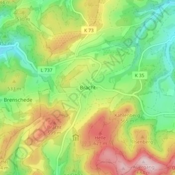
Bracht topographic map
Interactive map
Click on the map to display elevation.
About this map
Name: Bracht topographic map, elevation, terrain.
Average elevation: 496 m
Minimum elevation: 364 m
Maximum elevation: 680 m
Other topographic maps
Click on a map to view its topography, its elevation and its terrain.
Bad Fredeburg
Duitsland > Noordrijn-Westfalen > Hochsauerlandkreis > Schmallenberg
Bad Fredeburg, Schmallenberg, Hochsauerlandkreis, Noordrijn-Westfalen, 57392, Duitsland
Average elevation: 507 m
Oberkirchen
Duitsland > Noordrijn-Westfalen > Hochsauerlandkreis > Schmallenberg
Oberkirchen, Schmallenberg, Hochsauerlandkreis, Noordrijn-Westfalen, 57392, Duitsland
Average elevation: 530 m
Latrop
Duitsland > Noordrijn-Westfalen > Hochsauerlandkreis > Schmallenberg > Latrop
Latrop, Schmallenberg, Hochsauerlandkreis, Noordrijn-Westfalen, Duitsland
Average elevation: 590 m
Sellinghausen
Duitsland > Noordrijn-Westfalen > Hochsauerlandkreis > Schmallenberg > Mailar > Sellinghausen
Sellinghausen, Mailar, Schmallenberg, Hochsauerlandkreis, Noordrijn-Westfalen, Duitsland
Average elevation: 462 m