
Sunny Isles Beach topographic map
Interactive map
Click on the map to display elevation.
About this map
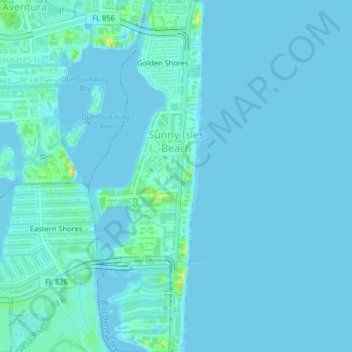
Name: Sunny Isles Beach topographic map, elevation, terrain.
Location: Sunny Isles Beach, Miami-Dade County, Florida, United States (25.92096 -80.13197 25.95714 -80.11868)
Average elevation: 4 m
Minimum elevation: -2 m
Maximum elevation: 36 m
Other topographic maps
Click on a map to view its topography, its elevation and its terrain.
Golden Shores
United States > Florida > Miami-Dade County > Sunny Isles Beach
Golden Shores, Sunny Isles Beach, Miami-Dade County, Florida, 33160, United States
Average elevation: 4 m