
Saint-Sorlin topographic map
Interactive map
Click on the map to display elevation.
About this map
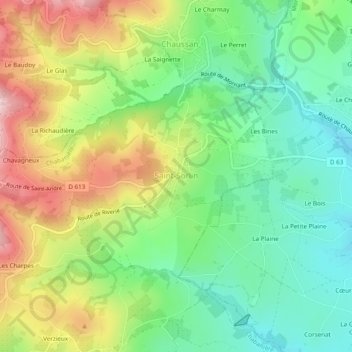
Name: Saint-Sorlin topographic map, elevation, terrain.
Average elevation: 467 m
Minimum elevation: 351 m
Maximum elevation: 648 m
Saint-Sorlin est à 500 m d’altitude et se situe au sud-ouest de Lyon, à environ cinq minutes de Mornant.
Other topographic maps
Click on a map to view its topography, its elevation and its terrain.
Haut-Barbieux
France > Auvergne-Rhône-Alpes > Rhône > Chabanière > Saint-Didier-sous-Riverie > Haut-Barbieux
Haut-Barbieux, Saint-Didier-sous-Riverie, Chabanière, Lyon, Rhône, Circonscription départementale du Rhône, Auvergne-Rhône-Alpes, France métropolitaine, 69440, France
Average elevation: 497 m
La Saulée
France > Auvergne-Rhône-Alpes > Rhône > Chabanière > Saint-Didier-sous-Riverie
La Saulée, Saint-Didier-sous-Riverie, Chabanière, Lyon, Rhône, Circonscription départementale du Rhône, Auvergne-Rhône-Alpes, France métropolitaine, 69440, France
Average elevation: 499 m
La Villonnière
France > Auvergne-Rhône-Alpes > Rhône > Chabanière > Saint-Maurice-sur-Dargoire
La Villonnière, Saint-Maurice-sur-Dargoire, Chabanière, Lyon, Rhône, Auvergne-Rhône-Alpes, France métropolitaine, 69440, France
Average elevation: 403 m