
Blue Earth Lake Provincial Park topographic map
Interactive map
Click on the map to display elevation.
About this map
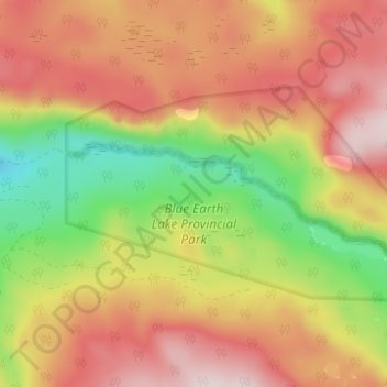
Name: Blue Earth Lake Provincial Park topographic map, elevation, terrain.
Average elevation: 1,540 m
Minimum elevation: 1,298 m
Maximum elevation: 1,743 m
Other topographic maps
Click on a map to view its topography, its elevation and its terrain.
Black Canyon
Canada > British Columbia > Thompson-Nicola Regional District > Area I (Blue Sky Country)
Black Canyon, Area I (Blue Sky Country), Thompson-Nicola Regional District, British Columbia, Canada
Average elevation: 386 m
Spences Bridge
Canada > British Columbia > Thompson-Nicola Regional District > Area I (Blue Sky Country)
Spences Bridge, Area I (Blue Sky Country), Thompson-Nicola Regional District, British Columbia, V0K 2L0, Canada
Average elevation: 495 m