
Wimbach topographic map
Interactive map
Click on the map to display elevation.
About this map
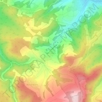
Name: Wimbach topographic map, elevation, terrain.
Location: Wimbach, Adenau, Landkreis Ahrweiler, Rijnland-Palts, Duitsland (50.34914 6.87508 50.38051 6.92896)
Average elevation: 456 m
Minimum elevation: 306 m
Maximum elevation: 610 m
Other topographic maps
Click on a map to view its topography, its elevation and its terrain.
Eifel
Duitsland > Rijnland-Palts > Landkreis Ahrweiler > Adenau
Eifel, Adenau, Landkreis Ahrweiler, Rijnland-Palts, Duitsland
Average elevation: 585 m
Senscheid
Duitsland > Rijnland-Palts > Landkreis Ahrweiler
Senscheid, Adenau, Landkreis Ahrweiler, Rijnland-Palts, Duitsland
Average elevation: 454 m
Antweiler
Duitsland > Rijnland-Palts > Landkreis Ahrweiler
Antweiler, Adenau, Landkreis Ahrweiler, Rijnland-Palts, Duitsland
Average elevation: 390 m
Nürburg
Duitsland > Rijnland-Palts > Landkreis Ahrweiler
Nürburg, Adenau, Landkreis Ahrweiler, Rijnland-Palts, Duitsland
Average elevation: 560 m
Remagen
Duitsland > Rijnland-Palts > Landkreis Ahrweiler
Remagen, Landkreis Ahrweiler, Rijnland-Palts, 53179, Duitsland, Rodderberg
Average elevation: 112 m
Ohlenhard
Duitsland > Rijnland-Palts > Landkreis Ahrweiler
Ohlenhard, Adenau, Landkreis Ahrweiler, Rijnland-Palts, Duitsland
Average elevation: 459 m
Meuspath
Duitsland > Rijnland-Palts > Landkreis Ahrweiler
Meuspath, Adenau, Landkreis Ahrweiler, Rijnland-Palts, Duitsland
Average elevation: 538 m
Laacher See
Duitsland > Rijnland-Palts > Landkreis Ahrweiler > Glees
Laacher See, Glees, Brohltal, Landkreis Ahrweiler, Rijnland-Palts, Duitsland
Average elevation: 314 m
Herschbroich
Duitsland > Rijnland-Palts > Landkreis Ahrweiler > Herschbroich
Herschbroich, Adenau, Landkreis Ahrweiler, Rijnland-Palts, Duitsland
Average elevation: 479 m