
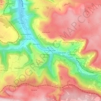
Pont les Bains topographic map
Interactive map
Click on the map to display elevation.
About this map
Name: Pont les Bains topographic map, elevation, terrain.
Average elevation: 465 m
Minimum elevation: 287 m
Maximum elevation: 593 m
Other topographic maps
Click on a map to view its topography, its elevation and its terrain.
Solsac
France > Occitanie > Aveyron > Salles-la-Source
Solsac, Salles-la-Source, Rodez, Aveyron, Occitanie, France métropolitaine, 12330, France
Average elevation: 496 m
Picardie Haute
France > Occitanie > Aveyron > Salles-la-Source
Picardie Haute, Cadoul, Salles-la-Source, Rodez, Aveyron, Occitanie, France métropolitaine, 12330, France
Average elevation: 553 m
Séveyrac
France > Occitanie > Aveyron > Salles-la-Source
Séveyrac, Salles-la-Source, Rodez, Aveyron, Occitanie, France métropolitaine, 12330, France
Average elevation: 505 m
Cadayrac
France > Occitanie > Aveyron > Salles-la-Source
Cadayrac, Salles-la-Source, Rodez, Aveyron, Occitanie, France métropolitaine, 12330, France
Average elevation: 551 m
Grisoles
France > Occitanie > Aveyron > Salles-la-Source
Grisoles, Salles-la-Source, Rodez, Aveyron, Occitanie, France métropolitaine, 12330, France
Average elevation: 520 m
Saint-Laurent
France > Occitanie > Aveyron > Salles-la-Source
Saint-Laurent, Salles-la-Source, Rodez, Aveyron, Occitanie, France métropolitaine, 12330, France
Average elevation: 522 m