
Melle topographic map
Interactive map
Click on the map to display elevation.
About this map
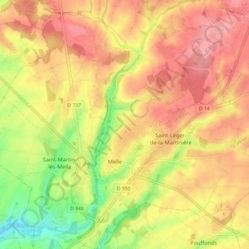
Name: Melle topographic map, elevation, terrain.
Average elevation: 137 m
Minimum elevation: 78 m
Maximum elevation: 176 m
Other topographic maps
Click on a map to view its topography, its elevation and its terrain.
Le Petit Beauvais
France > Nouvelle-Aquitaine > Deux-Sèvres > Melle
Le Petit Beauvais, Mazières-sur-Béronne, Melle, Niort, Deux-Sèvres, Nouvelle-Aquitaine, France métropolitaine, 79500, France
Average elevation: 84 m
Les Epinards
France > Nouvelle-Aquitaine > Deux-Sèvres > Melle
Les Epinards, Saint-Léger-de-la-Martinière, Melle, Niort, Deux-Sèvres, Nouvelle-Aquitaine, France métropolitaine, 79500, France
Average elevation: 152 m
Gachet
France > Nouvelle-Aquitaine > Deux-Sèvres > Melle
Gachet, Saint-Léger-de-la-Martinière, Melle, Niort, Deux-Sèvres, Nouvelle-Aquitaine, France métropolitaine, 79500, France
Average elevation: 139 m
Mazières-sur-Béronne
France > Nouvelle-Aquitaine > Deux-Sèvres > Melle
Mazières-sur-Béronne, Melle, Niort, Deux-Sèvres, Nouvelle-Aquitaine, France métropolitaine, 79500, France
Average elevation: 94 m