
Lhamo Latso topographic map
Interactive map
Click on the map to display elevation.
About this map
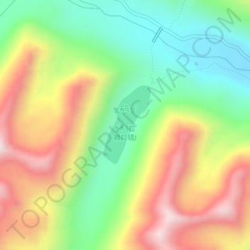
Name: Lhamo Latso topographic map, elevation, terrain.
Location: Lhamo Latso, Cuijiu, Gyatsa County, Shannan, Tibet, China (29.51270 92.73542 29.52118 92.74139)
Average elevation: 5,104 m
Minimum elevation: 4,811 m
Maximum elevation: 5,473 m
Lhamo Latso... [is] a brilliant azure jewel set in a ring of grey mountains. The elevation and the surrounding peaks combine to give it a highly changeable climate, and the continuous passage of cloud and wind creates a constantly moving pattern on the surface of the waters. On that surface visions appear to those who seek them in the right frame of mind.