
Anse à Dinand topographic map
Interactive map
Click on the map to display elevation.
About this map
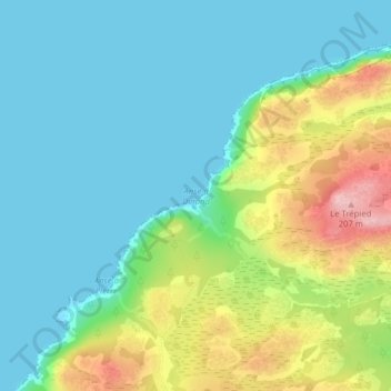
Name: Anse à Dinand topographic map, elevation, terrain.
Location: Anse à Dinand, Saint-Pierre en Miquelon, 97500, Frankrijk (46.80269 -56.19962 46.80279 -56.19952)
Average elevation: 57 m
Minimum elevation: 0 m
Maximum elevation: 204 m
Other topographic maps
Click on a map to view its topography, its elevation and its terrain.
Les Canailles
Frankrijk > Saint-Pierre en Miquelon > Saint-Pierre
Les Canailles, Saint-Pierre, Saint-Pierre en Miquelon, 97500, Frankrijk
Average elevation: 0 m