
Make a donation
Helvellyn topographic map
Click on the map to display elevation.
Make a donation
Helvellyn
Red Tarn, a classic corrie tarn, is a high-elevation tarn with low nutrient levels and poor in the number of species it supports. Characteristic vegetation zones include a water-starwort (Callitriche) in shallower areas and the alga Nitella flexilis in deeper water and around the inlet. Other species include a pondweed (Potamogeton) which grows in 2–3 m (7–10 ft) of water and the rush Juncus bulbosus. Brown trout and schelly, a species of whitefish, are found in the tarn.
Make a donation
About this map
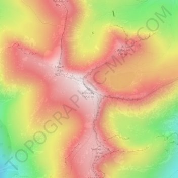
Name: Helvellyn topographic map, elevation, terrain.
Average elevation: 680 m
Minimum elevation: 277 m
Maximum elevation: 943 m
Make a donation
Other topographic maps
Click on a map to view its topography, its elevation and its terrain.
Brown Cove Tarn
United Kingdom > England > Westmorland and Furness > Patterdale
Average elevation: 699 m
Brothers Water
United Kingdom > England > Westmorland and Furness > Patterdale > Hartsop
Average elevation: 298 m
Make a donation