
Candelaria topographic map
Interactive map
Click on the map to display elevation.
About this map
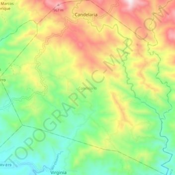
Name: Candelaria topographic map, elevation, terrain.
Location: Candelaria, Lempira, Honduras (14.01331 -88.60354 14.09739 -88.51801)
Average elevation: 489 m
Minimum elevation: 118 m
Maximum elevation: 1,043 m
Other topographic maps
Click on a map to view its topography, its elevation and its terrain.
San Sebastián
Honduras > Lempira > San Sebastián
San Sebastián, Lempira, Honduras
Average elevation: 1,514 m
Parque Nacional Celaque
Parque Nacional Celaque, Gracias, Lempira, Honduras
Average elevation: 1,759 m
Cerro Las Minas
Cerro Las Minas, Gracias, Lempira, Honduras
Average elevation: 2,531 m