
Pyrénées-Atlantiques topographic map
Interactive map
Click on the map to display elevation.
About this map
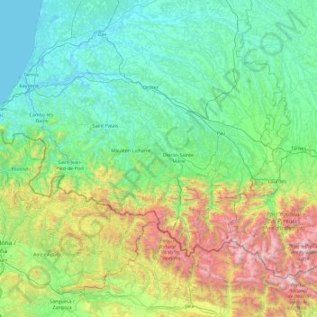
Name: Pyrénées-Atlantiques topographic map, elevation, terrain.
Average elevation: 607 m
Minimum elevation: -1 m
Maximum elevation: 3,247 m
Other topographic maps
Click on a map to view its topography, its elevation and its terrain.
Dissay
France > Nouvelle-Aquitaine > Vienne
Dissay, Poitiers, Vienne, Nouvelle-Aquitaine, Metropolitan France, 86130, France
Average elevation: 84 m
Goust
France > Nouvelle-Aquitaine > Pyrénées-Atlantiques > Laruns
Goust, Laruns, Oloron-Sainte-Marie, Pyrénées-Atlantiques, Nouvelle-Aquitaine, Metropolitan France, 64440, France
Average elevation: 1,193 m