
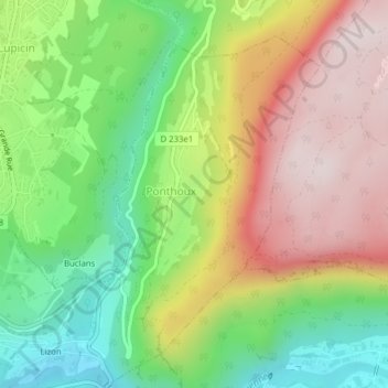
Ponthoux topographic map
Interactive map
Click on the map to display elevation.
About this map
Name: Ponthoux topographic map, elevation, terrain.
Average elevation: 618 m
Minimum elevation: 361 m
Maximum elevation: 911 m
Other topographic maps
Click on a map to view its topography, its elevation and its terrain.
Brive
France > Bourgogne-Franche-Comté > Jura > Lavans-lès-Saint-Claude
Brive, Lavans-lès-Saint-Claude, Saint-Claude, Jura, Bourgogne-Franche-Comté, France métropolitaine, 39170, France
Average elevation: 534 m
Lizon
France > Bourgogne-Franche-Comté > Jura > Lavans-lès-Saint-Claude > Lizon
Lizon, Lavans-lès-Saint-Claude, Saint-Claude, Jura, Bourgogne-Franche-Comté, France métropolitaine, 39170, France
Average elevation: 564 m
Petit Châtel
France > Bourgogne-Franche-Comté > Jura > Lavans-lès-Saint-Claude
Petit Châtel, Pratz, Lavans-lès-Saint-Claude, Saint-Claude, Jura, Bourgogne-Franche-Comté, France métropolitaine, 39170, France
Average elevation: 627 m