
Gors-Opleeuw topographic map
Interactive map
Click on the map to display elevation.
About this map
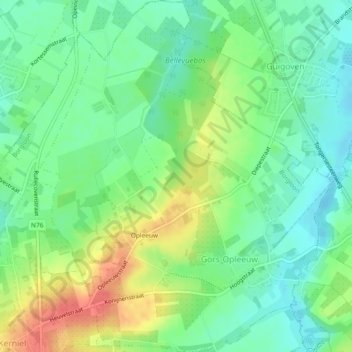
Name: Gors-Opleeuw topographic map, elevation, terrain.
Location: Gors-Opleeuw, Borgloon, Tongeren, Limburg, Vlaanderen, België (50.81619 5.36697 50.84543 5.40610)
Average elevation: 71 m
Minimum elevation: 47 m
Maximum elevation: 107 m
Other topographic maps
Click on a map to view its topography, its elevation and its terrain.
Kasteel van Gors
België > Limburg > Tongeren > Borgloon > Gors-Opleeuw > Gors
Kasteel van Gors, 35, Hoogstraat, Gors, Gors-Opleeuw, Borgloon, Tongeren, Limburg, Vlaanderen, 3840, België
Average elevation: 73 m
Sassenbroek
België > Limburg > Tongeren > Borgloon
Sassenbroek, Broekom, Borgloon, Tongeren, Limburg, Vlaanderen, 3840, België
Average elevation: 81 m
Hoepertingen
België > Limburg > Tongeren > Borgloon
Hoepertingen, Borgloon, Tongeren, Limburg, België
Average elevation: 64 m