
Winklmoosalm topographic map
Interactive map
Click on the map to display elevation.
About this map
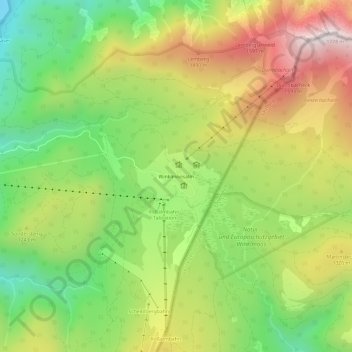
Name: Winklmoosalm topographic map, elevation, terrain.
Average elevation: 1,193 m
Minimum elevation: 749 m
Maximum elevation: 1,739 m
Other topographic maps
Click on a map to view its topography, its elevation and its terrain.
Walmberg
Deutschland > Bayern > Landkreis Traunstein > Reit im Winkl
Walmberg, Reit im Winkl, Landkreis Traunstein, Bayern, 83242, Deutschland
Average elevation: 836 m
Wetterkreuz
Deutschland > Bayern > Landkreis Traunstein > Reit im Winkl
Wetterkreuz, Reit im Winkl, Landkreis Traunstein, Bayern, 83242, Deutschland
Average elevation: 890 m
Groißenbach
Deutschland > Bayern > Landkreis Traunstein > Reit im Winkl > Groißenbach
Groißenbach, Reit im Winkl, Landkreis Traunstein, Bayern, 83242, Deutschland
Average elevation: 818 m
Hausbachfall
Deutschland > Bayern > Landkreis Traunstein > Reit im Winkl
Hausbachfall, Reit im Winkl, Landkreis Traunstein, Bayern, 83242, Deutschland
Average elevation: 854 m
Seegatterl
Deutschland > Bayern > Landkreis Traunstein > Reit im Winkl > Seegatterl
Seegatterl, Reit im Winkl, Landkreis Traunstein, Bayern, Deutschland
Average elevation: 1,031 m