
Bethlehem topographic map
Interactive map
Click on the map to display elevation.
About this map
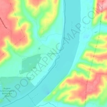
Name: Bethlehem topographic map, elevation, terrain.
Location: Bethlehem, Clark County, Indiana, 47104, United States (38.51923 -85.44051 38.55923 -85.40051)
Average elevation: 170 m
Minimum elevation: 124 m
Maximum elevation: 258 m
Other topographic maps
Click on a map to view its topography, its elevation and its terrain.
Starlight
United States > Indiana > Clark County
Starlight, Clark County, Indiana, 47106, United States
Average elevation: 255 m
Underwood
United States > Indiana > Clark County
Underwood, Clark County, Indiana, 47177, United States
Average elevation: 194 m
Rolling Hills
United States > Indiana > Clark County
Rolling Hills, Clark County, Indiana, United States
Average elevation: 196 m
Henryville
United States > Indiana > Clark County
Henryville, Clark County, Indiana, 47126, United States
Average elevation: 166 m
Marysville
United States > Indiana > Clark County
Marysville, Clark County, Indiana, United States
Average elevation: 211 m
Otisco
United States > Indiana > Clark County
Otisco, Clark County, Indiana, 47163, United States
Average elevation: 198 m
Nabb
United States > Indiana > Clark County
Nabb, Clark County, Indiana, United States
Average elevation: 212 m
New Washington
United States > Indiana > Clark County
New Washington, Clark County, Indiana, United States
Average elevation: 214 m
Oak Park
United States > Indiana > Clark County
Oak Park, Clark County, Indiana, United States
Average elevation: 140 m
Borden
United States > Indiana > Clark County
Borden, Clark County, Indiana, United States
Average elevation: 220 m
Sellersburg
United States > Indiana > Clark County
Sellersburg, Clark County, Indiana, 47172, United States
Average elevation: 149 m
Memphis
United States > Indiana > Clark County
Memphis, Clark County, Indiana, United States
Average elevation: 153 m
Port Fulton
United States > Indiana > Clark County > Jeffersonville
Port Fulton, Jeffersonville, Clark County, Indiana, 47130, United States
Average elevation: 140 m
Jeffersonville
United States > Indiana > Clark County
Jeffersonville, Clark County, Indiana, United States
Average elevation: 150 m
Charlestown
United States > Indiana > Clark County
Charlestown, Clark County, Indiana, 47111, United States
Average elevation: 170 m
Owen
United States > Indiana > Clark County
Owen, Clark County, Indiana, United States
Average elevation: 182 m
Utica
United States > Indiana > Clark County
Utica, Clark County, Indiana, United States
Average elevation: 142 m
Speed
United States > Indiana > Clark County > Speed
Speed, Clark County, Indiana, 47172, United States
Average elevation: 147 m
Clarksville
United States > Indiana > Clark County
Clarksville, Clark County, Indiana, United States
Average elevation: 150 m