
Thank you for supporting this site ❤️
Make a donation
Make a donation
Ffostrasol topographic map
Click on the map to display elevation.
Thank you for supporting this site ❤️
Make a donation
Make a donation
About this map
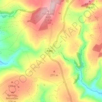
Name: Ffostrasol topographic map, elevation, terrain.
Average elevation: 230 m
Minimum elevation: 120 m
Maximum elevation: 327 m
Thank you for supporting this site ❤️
Make a donation
Make a donation
Other topographic maps
Click on a map to view its topography, its elevation and its terrain.
Thank you for supporting this site ❤️
Make a donation
Make a donation
Thank you for supporting this site ❤️
Make a donation
Make a donation
Newcastle Emlyn Castle
United Kingdom > Wales > Ceredigion > Adpar > Bryndioddef
Average elevation: 78 m
Thank you for supporting this site ❤️
Make a donation
Make a donation
Thank you for supporting this site ❤️
Make a donation
Make a donation