
Coyomeapan topographic map
Interactive map
Click on the map to display elevation.
About this map
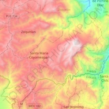
Name: Coyomeapan topographic map, elevation, terrain.
Location: Coyomeapan, Puebla, Mexique (18.18979 -97.10041 18.38167 -96.84659)
Average elevation: 1,825 m
Minimum elevation: 119 m
Maximum elevation: 3,274 m
Other topographic maps
Click on a map to view its topography, its elevation and its terrain.
Tlacotepec de Díaz
Mexique > Puebla > San Sebastián Tlacotepec > Tlacotepec de Porfirio Díaz
Tlacotepec de Díaz, Tlacotepec de Porfirio Díaz, San Sebastián Tlacotepec, Puebla, 75940, Mexique
Average elevation: 455 m
La Cantera
Mexique > Puebla > Tlahuapan > Santa Rita Tlahuapan
La Cantera, Santa Rita Tlahuapan, Tlahuapan, Puebla, Mexique
Average elevation: 2,669 m
Tlaxcalancingo (San Bernardino)
Mexique > Puebla > Tlaxcalancingo (San Bernardino)
Tlaxcalancingo (San Bernardino), San Andrés Cholula, Puebla, 72821, Mexique
Average elevation: 2,123 m