
How Mill topographic map
Interactive map
Click on the map to display elevation.
About this map
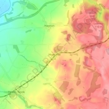
Name: How Mill topographic map, elevation, terrain.
Location: How Mill, Cumberland, England, CA8 9JT, United Kingdom (54.88166 -2.78611 54.92166 -2.74611)
Average elevation: 90 m
Minimum elevation: 20 m
Maximum elevation: 150 m
Other topographic maps
Click on a map to view its topography, its elevation and its terrain.
Carlisle
United Kingdom > England > Cumberland
Carlisle, Cumberland, England, United Kingdom
Average elevation: 31 m
Thirlmere
United Kingdom > England > Cumberland > Legburthwaite
Thirlmere, Legburthwaite, Cumberland, England, United Kingdom
Average elevation: 446 m
Keswick
United Kingdom > England > Cumberland
Keswick, Cumberland, England, United Kingdom
Average elevation: 128 m
Scafell Pike
United Kingdom > England > Cumberland
Scafell Pike, Cumberland, England, CA20 1EX, United Kingdom
Average elevation: 679 m