
Cospeito topographic map
Interactive map
Click on the map to display elevation.
About this map
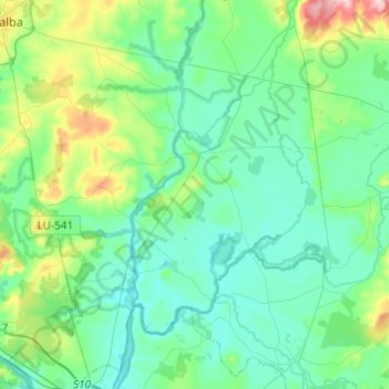
Name: Cospeito topographic map, elevation, terrain.
Location: Cospeito, Terra Chá, Lugo, Galice, Espagne (43.15320 -7.65733 43.28131 -7.41328)
Average elevation: 425 m
Minimum elevation: 382 m
Maximum elevation: 593 m
Other topographic maps
Click on a map to view its topography, its elevation and its terrain.
Baltar
Espagne > Galice > Terra Chá > A Pastoriza
Baltar, A Pastoriza, Terra Chá, Lugo, Galice, Espagne
Average elevation: 462 m
Castro de Rei
Espagne > Galice > Terra Chá > Castro de Rei
Castro de Rei, Terra Chá, Lugo, Galice, Espagne
Average elevation: 505 m