
Tesso Nilo National Park topographic map
Interactive map
Click on the map to display elevation.
About this map
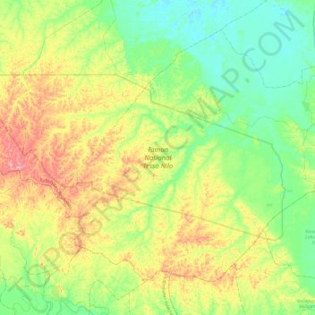
Name: Tesso Nilo National Park topographic map, elevation, terrain.
Average elevation: 64 m
Minimum elevation: 3 m
Maximum elevation: 183 m
Other topographic maps
Click on a map to view its topography, its elevation and its terrain.
Kecamatan Pangkalan Kerinci
Indonesia > Riau > Pelalawan Regency
Kecamatan Pangkalan Kerinci, Pelalawan Regency, Riau, 28654, Indonesia
Average elevation: 14 m
Pelalawan
Indonesia > Riau > Pelalawan Regency
Pelalawan, Kecamatan Pelalawan, Pelalawan Regency, Riau, Indonesia
Average elevation: 7 m