
Terengganu topographic map
Interactive map
Click on the map to display elevation.
About this map
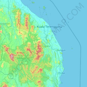
Name: Terengganu topographic map, elevation, terrain.
Location: Terengganu, Malaysia (3.88135 102.37847 5.96413 103.69100)
Average elevation: 144 m
Minimum elevation: -1 m
Maximum elevation: 2,125 m
Other topographic maps
Click on a map to view its topography, its elevation and its terrain.
Kampung Seberang Takir Hulu
Malaysia > Terengganu > Kampung Seberang Takir Hulu
Kampung Seberang Takir Hulu, Terengganu, 20000, Malaysia
Average elevation: 3 m
Kuala Terengganu
Malaysia > Terengganu > Kuala Terengganu
Kuala Terengganu, Terengganu, 20200, Malaysia
Average elevation: 9 m