
Bondsville topographic map
Interactive map
Click on the map to display elevation.
About this map
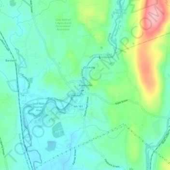
Name: Bondsville topographic map, elevation, terrain.
Average elevation: 130 m
Minimum elevation: 91 m
Maximum elevation: 236 m
Other topographic maps
Click on a map to view its topography, its elevation and its terrain.
Forest Lake
United States > Massachusetts > Hampden County > Palmer > Whipples
Forest Lake, Whipples, Palmer, Hampden County, Massachusetts, United States
Average elevation: 149 m
Three Rivers Well Field
United States > Massachusetts > Hampden County > Palmer > Four Corners
Three Rivers Well Field, Four Corners, Palmer, Hampden County, Massachusetts, United States
Average elevation: 110 m
Blanchardville
United States > Massachusetts > Hampden County > Palmer
Blanchardville, Palmer, Hampden County, Massachusetts, 01069, United States
Average elevation: 156 m