
Blue Ridge Summit topographic map
Interactive map
Click on the map to display elevation.
About this map
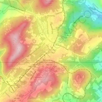
Name: Blue Ridge Summit topographic map, elevation, terrain.
Average elevation: 400 m
Minimum elevation: 244 m
Maximum elevation: 516 m
Other topographic maps
Click on a map to view its topography, its elevation and its terrain.
Zullinger
United States > Pennsylvania > Franklin County > Washington Township
Zullinger, Washington Township, Franklin County, Pennsylvania, 17272, United States
Average elevation: 216 m
Pen Mar
United States > Pennsylvania > Franklin County > Washington Township
Pen Mar, Washington Township, Franklin County, Pennsylvania, 17250, United States
Average elevation: 365 m
Rouzerville
United States > Pennsylvania > Franklin County > Washington Township > Rouzerville
Rouzerville, Washington Township, Franklin County, Pennsylvania, 17250, United States
Average elevation: 228 m
Wayne Heights
United States > Pennsylvania > Franklin County > Washington Township
Wayne Heights, Washington Township, Franklin County, Pennsylvania, United States
Average elevation: 211 m
Monterey
United States > Pennsylvania > Franklin County > Washington Township
Monterey, Washington Township, Franklin County, Pennsylvania, 17214, United States
Average elevation: 403 m