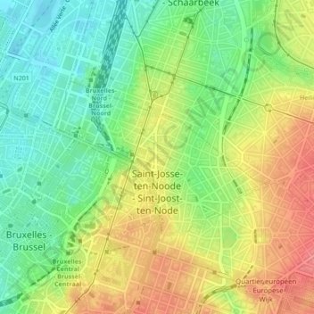
Sint-Joost-ten-Node topographic map
Interactive map
Click on the map to display elevation.
About this map
Name: Sint-Joost-ten-Node topographic map, elevation, terrain.
Average elevation: 47 m
Minimum elevation: 13 m
Maximum elevation: 86 m

Click on the map to display elevation.
Name: Sint-Joost-ten-Node topographic map, elevation, terrain.
Average elevation: 47 m
Minimum elevation: 13 m
Maximum elevation: 86 m