
Point Peron (S3) topographic map
Click on the map to display elevation.
About this map
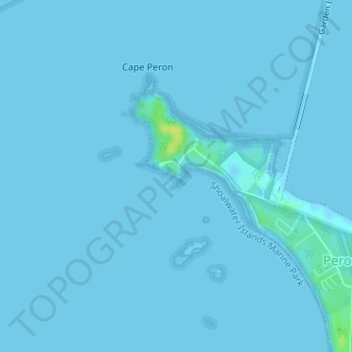
Name: Point Peron (S3) topographic map, elevation, terrain.
Average elevation: 1 m
Minimum elevation: -3 m
Maximum elevation: 19 m
Other topographic maps
Click on a map to view its topography, its elevation and its terrain.
Perth
Perth, the capital of Western Australia, is situated on the Swan Coastal Plain, a flat expanse of sandy soil nestled between the Indian Ocean to the west and the Darling Scarp to the east. The Darling Scarp, also known as the Darling Range, is a low escarpment that extends north–south, marking a distinct…
Average elevation: 26 m
Rockingham
Australia > Western Australia > Rockingham
Rockingham is topographically flat, has sandy soils and coastal vegetation. It has a northern aspect to Cockburn Sound, from Rockingham Beach and Palm Beach.
Average elevation: 4 m
Purnululu National Park
The Bungle Bungle Range, lying fully within the park, has elevations as high as 578 metres (1,896 ft) above sea level. It is famous for the sandstone domes, unusual and visually striking with their striping in alternating orange and grey bands. The banding of the domes is due to differences in clay content and…
Average elevation: 277 m
Nullarbor Plain
Australia > Western Australia > Forrest
One theory is that the whole area was uplifted by crustal movements in the Miocene, and since then, erosion by wind and rain has reduced its thickness. The plain has most likely never had any major defining topographic features, resulting in the extremely flat terrain across the plain today.
Average elevation: 131 m
Mount Barker
The peak of Mount Barker lies 3.5 kilometres (2.2 mi) southwest of the town centre, and reaches an elevation of 404 metres (1,325 ft) above sea level. A sealed road leads to the base of a radio and television tower on the summit of the hill. The tower was constructed to a height of 168 metres (551 ft) in 1966,…
Average elevation: 211 m
The Vines
Topographically, The Vines sits on a gradual incline that descends towards the Ellen Brook valley. The west of the suburb sits at 30 metres above sea level, dropping to 20 metres in the east around the brook and the Sawpit Gully.
Average elevation: 27 m
Clackline
Clackline Bridge is a historic road bridge in Clackline that carried the Great Eastern Highway until 2008. It is the only bridge in Western Australia to have spanned both a waterway and railway, the Clackline Brook and the former Eastern Railway alignment. The mainly timber bridge has a unique curved and…
Average elevation: 286 m
Exmouth
In 2009, an emergency landing of the flight Qantas 72 was made at the nearby Learmonth Airport / RAAF Base Learmonth. The A330 had an incident involving the ADIRU which confused AoA (Angle of Attack) data with altitude data, making the plane think it was in a 16° pitch up when it was flying level. So the…
Average elevation: 27 m