
Errenteria topographic map
Interactive map
Click on the map to display elevation.
About this map
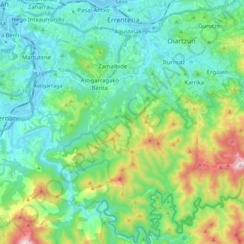
Name: Errenteria topographic map, elevation, terrain.
Average elevation: 190 m
Minimum elevation: -2 m
Maximum elevation: 781 m
Other topographic maps
Click on a map to view its topography, its elevation and its terrain.
Oiartzun
Spain > Autonomous Community of the Basque Country > Donostialdea
Oiartzun, Donostialdea, Gipuzkoa, Autonomous Community of the Basque Country, 20180, Spain
Average elevation: 251 m
Pasaia
Spain > Autonomous Community of the Basque Country > Donostialdea
Pasaia, Donostialdea, Gipuzkoa, Autonomous Community of the Basque Country, 20110, Spain
Average elevation: 40 m
Donostia / San Sebastián
Spain > Autonomous Community of the Basque Country > Donostialdea > Donostia / San Sebastián
Donostia / San Sebastián, San Sebastián, Donostialdea, Gipuzkoa, Autonomous Community of the Basque Country, 20003, Spain
Average elevation: 134 m
Zikuñaga
Spain > Autonomous Community of the Basque Country > Donostialdea > Hernani > Zikuñaga
Zikuñaga, Hernani, Donostialdea, Gipuzkoa, Autonomous Community of the Basque Country, 20120, Spain
Average elevation: 62 m
Usurbil
Spain > Autonomous Community of the Basque Country > Donostialdea
Usurbil, Donostialdea, Gipuzkoa, Autonomous Community of the Basque Country, 20170, Spain
Average elevation: 138 m