
Grapeview topographic map
Interactive map
Click on the map to display elevation.
About this map
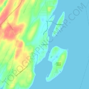
Name: Grapeview topographic map, elevation, terrain.
Location: Grapeview, Mason County, Washington, United States (47.31176 -122.85514 47.35176 -122.81514)
Average elevation: 21 m
Minimum elevation: 0 m
Maximum elevation: 81 m
Other topographic maps
Click on a map to view its topography, its elevation and its terrain.
Matlock
United States > Washington > Mason County
Matlock, Mason County, Washington, 98560, United States
Average elevation: 133 m
Triton
United States > Washington > Mason County
Triton, Mason County, Washington, United States
Average elevation: 122 m
Shelton
United States > Washington > Mason County
Shelton, Mason County, Washington, United States
Average elevation: 54 m
Belfair
United States > Washington > Mason County
Belfair, Mason County, Washington, United States
Average elevation: 63 m
Harstine Island
United States > Washington > Mason County
Harstine Island, Mason County, Washington, United States
Average elevation: 30 m
Lake Cushman
United States > Washington > Mason County
Lake Cushman, Mason County, Washington, United States
Average elevation: 406 m
Lake Kokanee
United States > Washington > Mason County
Lake Kokanee, Mason County, Washington, United States
Average elevation: 214 m
Lake Wooten
United States > Washington > Mason County
Lake Wooten, Mason County, Washington, United States
Average elevation: 130 m
Allyn
United States > Washington > Mason County
Allyn, Mason County, Washington, 98524, United States
Average elevation: 45 m
Hoodsport
United States > Washington > Mason County
Hoodsport, Mason County, Washington, 98548, United States
Average elevation: 62 m
Shelton
United States > Washington > Mason County > Shelton > Shelton
Shelton, Mason County, Washington, United States
Average elevation: 55 m
Lilliwaup
United States > Washington > Mason County > Lilliwaup
Lilliwaup, Mason County, Washington, United States
Average elevation: 114 m
Tahuya
United States > Washington > Mason County
Tahuya, Mason County, Washington, 98588, United States
Average elevation: 49 m