
La Tercería topographic map
Interactive map
Click on the map to display elevation.
About this map
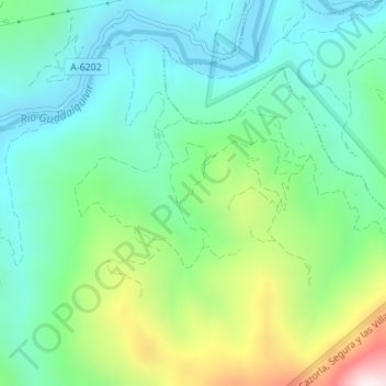
Name: La Tercería topographic map, elevation, terrain.
Average elevation: 715 m
Minimum elevation: 500 m
Maximum elevation: 1,257 m
Other topographic maps
Click on a map to view its topography, its elevation and its terrain.
Parque Natural Sierras de Cazorla, Segura y las Villas
Espanha > Andaluzia > Villanueva del Arzobispo
Parque Natural Sierras de Cazorla, Segura y las Villas, A-6202, Villanueva del Arzobispo, Jaén, Andaluzia, 23330, Espanha
Average elevation: 887 m