
Hennepin County topographic map
Interactive map
Click on the map to display elevation.
About this map
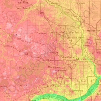
Name: Hennepin County topographic map, elevation, terrain.
Location: Hennepin County, Minnesota, United States of America (44.78513 -93.77020 45.24660 -93.17687)
Average elevation: 280 m
Minimum elevation: 190 m
Maximum elevation: 340 m
Other topographic maps
Click on a map to view its topography, its elevation and its terrain.
Beaver Creek
United States of America > Minnesota > Beaver Creek
Beaver Creek, Rock County, Minnesota, 56116, United States of America
Average elevation: 447 m
Bemidji
United States of America > Minnesota > Bemidji
Bemidji, Beltrami County, Minnesota, 56601, United States of America
Average elevation: 417 m
Winona County
United States of America > Minnesota
Winona County, Minnesota, United States of America
Average elevation: 309 m
Beltrami County
United States of America > Minnesota
Beltrami County, Minnesota, United States of America
Average elevation: 386 m
Clearwater County
United States of America > Minnesota
Clearwater County, Minnesota, United States of America
Average elevation: 409 m
Benton County
United States of America > Minnesota
Benton County, Minnesota, United States of America
Average elevation: 340 m